GEOTECHNICAL ENGINEERING
MEMPHIS
HomeGeophysicsMASW / VS30 (shear wave velocity)

MASW and VS30 Shear Wave Velocity Testing in Memphis, Tennessee

Technical studies that support your project.

LEARN MORE

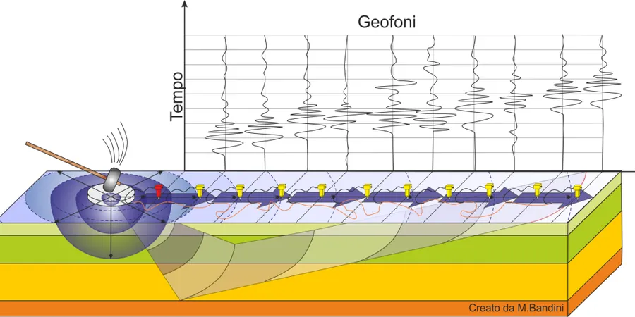
Memphis sits on the deep sediment-filled trough of the Mississippi Embayment, where loose sands and thick alluvium amplify seismic waves in ways that bedrock-based codes miss entirely. The 1811–1812 New Madrid earthquakes are a constant reminder that ground motion here can be severe even at distance. In our experience, a simple SPT-based site class often underestimates the hazard. The MASW technique gives you a direct, non-invasive Vs30 measurement that feeds straight into the ASCE 7 site classification. When the profile shows a soft clay cap over dense sand, we sometimes pair it with seismic refraction to map the top-of-bedrock depth across the site, especially near the Wolf River floodplain where channel deposits vary over tens of feet.

In the Mississippi Embayment, Vs30 alone does not tell the full story—basin depth effects can amplify long-period motion that standard site factors miss.

Our service areas

Methodology and scope

ASCE 7-22 Chapter 20 and the International Building Code require Vs30 for Site Class determination when local conditions suggest Site E or F. In Memphis, the geotechnical concern is twofold: the near-surface Mississippi River alluvium has very low shear wave velocity, and the deep basin geometry traps long-period energy. Our field crew uses a 24- or 48-channel seismograph with 4.5 Hz geophones and a 10 lb sledgehammer source—adequate for the 30-meter target depth in most of Shelby County. Data processing follows the SurfSeis dispersion workflow, extracting the fundamental-mode Rayleigh wave curve and inverting it to a layered Vs profile. We report Vs30 with the NEHRP site class and the site period Ts, because in this region the double-resonance risk between soil column and mid-rise structures is real.
The typical Memphis profile we see: 5 to 15 ft of sandy silt fill, underlain by 30 to 80 ft of Holocene alluvium, then the Jackson Formation clay at depth. The alluvium often shows Vs in the 150–220 m/s range, pushing sites into Site E without careful measurement.
MASW and VS30 Shear Wave Velocity Testing in Memphis, Tennessee
Technical reference — Memphis

Local considerations

A 24-channel seismograph array stretches roughly 70 meters across the site, with geophones planted in a straight line on grass or asphalt. The biggest challenge in Memphis is the summer humidity: geophone-ground coupling degrades when the surface clay dries and cracks, so we schedule surveys early morning after the dew settles or wet the contact points manually. Urban noise from freight trains on the Norfolk Southern line and heavy truck traffic on I-240 can contaminate the low-frequency part of the dispersion curve. We mitigate this by stacking multiple shots at each offset and monitoring the time-domain record for transient noise. The result is a clean fundamental-mode curve that resolves the upper 30 meters reliably, even at sites where the water table is within 10 ft and the alluvium is nearly saturated.

Need a geotechnical assessment?

Reply within 24h.

Email: contact@geotechnical-engineering1.org

Applicable standards

ASTM D4428/D4428M – Crosshole and Surface Seismic Testing, ASCE/SEI 7-22 Chapter 20 – Site Classification Procedure, 2024 International Building Code (IBC) – Seismic Provisions, NEHRP Recommended Seismic Provisions – Vs30 Site Factors, FHWA-NHI-05-037 – Geotechnical Site Characterization

Technical parameters

ParameterTypical value
Depth of Investigation (Vs30)30 m (98 ft) per NEHRP standard
Source TypeSledgehammer (10–16 lb) on aluminum strike plate
Geophone Frequency4.5 Hz vertical-component, 24–48 channels
Array ConfigurationLinear spread, 2–4 m receiver spacing
Applicable StandardASTM D4428/D4428M, ASCE 7-22 Ch. 20
Site Period Ts (optional)Computed from Vs profile per ASCE 7
Typical Memphis Vs range (alluvium)150–260 m/s in Holocene deposits

Frequently asked questions

What does a MASW test cost on a typical Memphis commercial lot?

For a standard Vs30 survey on a single-family or small commercial parcel in the Memphis area, the fee ranges from US$1,520 to US$2,860 depending on site access, array length, and whether we are also reporting the site period Ts. Larger multi-line surveys for plaza-scale projects are quoted per linear meter.

How long does the field work take and will it disrupt our site?

A single MASW line is typically completed in 1 to 2 hours. The array is laid on the ground surface and removed immediately—there is no drilling, no soil excavation, and no damage to pavement or landscaping. The sledgehammer impacts are brief and localized.

Why is Vs30 important in Memphis when we are not on the West Coast?

The New Madrid Seismic Zone generates infrequent but powerful earthquakes that propagate efficiently through the deep Mississippi Embayment sediments. Memphis sits on thick, low-velocity alluvium that amplifies ground motion. The IBC requires site-specific Vs30 because the default Site D assumption often underestimates the shaking hazard here. A measured Vs30 gives you a defensible site class, potentially reducing foundation costs if the profile is better than assumed.

Location and service area

We serve projects across Memphis and its metropolitan area.

View larger map